
Efficient land use is critical for the success of medium-to-large farms, where effective planning can significantly improve productivity, reduce costs, and increase sustainability. Proper farm planning starts with understanding the size, shape, and natural features of your land. Mapping the farm allows farmers to visualise crop zones, grazing areas, irrigation systems, and infrastructure such as roads, storage facilities, and equipment sheds. By assessing the terrain, soil types, water sources, and existing vegetation, you can make informed decisions about how to allocate resources and maximise output.
A key step in farm planning is creating a detailed farm map. This involves measuring and marking boundaries, slopes, and drainage systems, as well as identifying areas prone to erosion or flooding. Digital tools such as GPS mapping, drones, and farm management software can provide accurate and up-to-date information, enabling precision planning. Mapping also helps in planning crop rotation schedules, livestock grazing patterns, and placement of infrastructure, which can reduce labour requirements and improve operational efficiency.
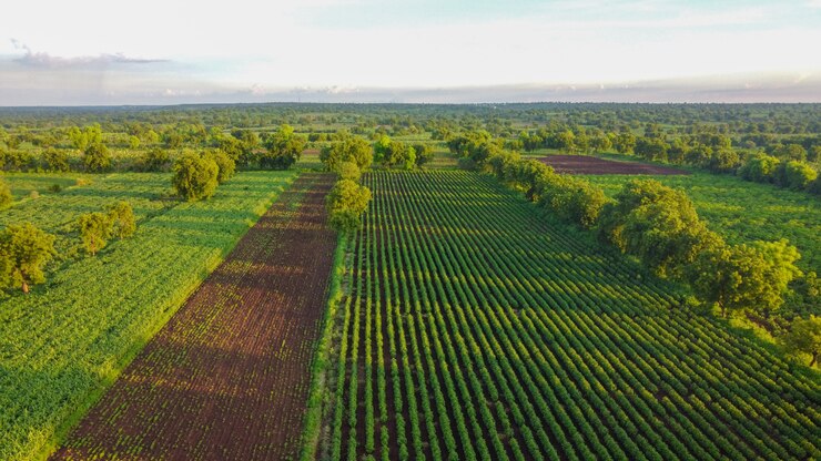
Zoning your farm according to land use is essential for medium-to-large operations. Different areas should be allocated for specific purposes such as arable crops, orchards, pasture, conservation areas, and buildings. High-quality soils and areas with optimal sunlight and water access should be prioritised for high-value crops, while less productive land can be used for grazing or conservation. Efficient zoning reduces resource wastage, supports soil health, and minimises conflicts between different farm activities.
Water management is another critical aspect of farm planning. Identifying natural water sources, designing irrigation networks, and installing water storage systems ensure that crops and livestock have reliable access to water throughout the year. Properly mapped irrigation layouts prevent over- or under-watering, reduce energy costs, and improve yield quality. Integrating water management into your farm map allows for effective planning of drainage systems, erosion control, and sustainability initiatives.
Finally, regularly reviewing and updating your farm plan is essential. Farms are dynamic systems, and soil fertility, market demands, and climate conditions can change over time. Updating maps, tracking resource use, and adjusting crop or grazing plans ensures that land is always used efficiently. By prioritising planning and mapping, medium-to-large farm owners can optimise production, enhance sustainability, and achieve long-term profitability.
Join 'Farmers Mag' WhatsApp Channel
Get the latest Farming news and tips delivered straight to your WhatsApp
CLICK HERE TO JOIN