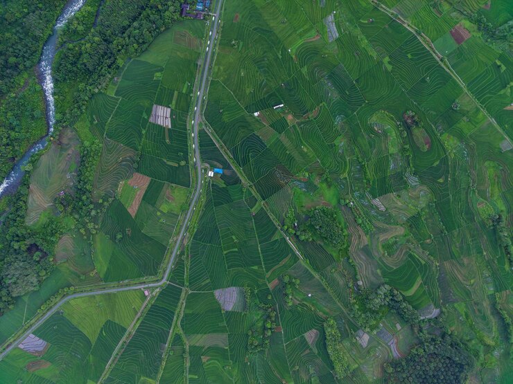
Satellite imagery is revolutionizing the way farmers plan and manage their operations. With high-resolution images and detailed data available at the click of a button, farmers can now make more informed decisions about everything from crop rotation and irrigation to soil health and yield optimization. Incorporating satellite data into farm planning leads to increased efficiency, reduced input costs, and improved productivity.
Using satellite imagery starts with understanding what kind of data is available and how it applies to a specific farm. Most satellite images used in agriculture come from sources like Sentinel, Landsat, or commercial satellites, which capture images at regular intervals. These images reveal variations in plant health, soil moisture, land use, and crop development over time. Farmers can access these images through platforms like Google Earth Engine, FarmLogs, or precision agriculture tools provided by agritech companies.
One of the most common uses of satellite imagery is monitoring crop health. Satellites detect differences in vegetation using spectral indices like NDVI (Normalized Difference Vegetation Index), which shows how green and healthy crops are in specific areas. By analyzing NDVI maps, farmers can identify stressed plants early, whether due to pests, diseases, nutrient deficiencies, or water stress. This allows for targeted intervention, rather than blanket spraying or fertilizing, which saves time and resources.
Soil analysis is another critical benefit. Satellite data can indicate areas of poor drainage, erosion, or compaction. When combined with yield maps or ground-truthing data, this information helps farmers plan corrective actions such as cover cropping, contour plowing, or soil amendment. Over time, these changes contribute to better soil structure and fertility, which supports more consistent yields.
Satellite imagery is also valuable for mapping field boundaries and planning new planting areas. For large-scale farms, accurately marking plots is essential for logistics and compliance with agricultural regulations. Updated images make it easier to spot changes in land use, encroachments, or issues like illegal dumping or deforestation around the farm.
In irrigation planning, satellites help track soil moisture and evaporation rates across fields. Farmers can use this data to fine-tune their irrigation schedules, apply water only where needed, and reduce water waste. This is particularly useful in dry or semi-arid regions where water is scarce and irrigation must be precise.
During planting and harvesting seasons, satellite imagery can inform timing decisions. By analyzing weather patterns and field readiness, farmers can plan sowing and harvesting to avoid losses due to early rains or extreme heat. Satellite data also supports crop forecasting, helping farmers estimate yields and make market decisions in advance.
To fully benefit from satellite imagery, farmers may need to invest in software tools or work with agronomists and data analysts who can interpret the images accurately. Some tools offer automated insights, while others provide raw data that require expert interpretation. Regardless of the approach, integrating satellite imagery into farm planning is increasingly cost-effective and accessible.
As climate variability and input costs rise, using satellite imagery is no longer a luxury but a necessity for modern farm planning. It provides a clear, real-time picture of the farm’s condition, helping farmers respond proactively and sustainably. Whether managing a small family farm or a large commercial enterprise, satellite data empowers farmers to make smarter, data-driven decisions that enhance both productivity and resilience.
Join 'Farmers Mag' WhatsApp Channel
Get the latest Farming news and tips delivered straight to your WhatsApp
CLICK HERE TO JOIN